|
In a desert where
Utah, Arizona, New Mexico, and Colorado form the four corners of the
Southwest, a canyon witnessed a great mystery. With short growing seasons and little rainfall, it became an unlikely
place for a civilization. Yet the
canyon was the center of the Anasazi Indian culture.
The
Pueblo Indians say that Chaco was a special gathering place, where tribes
met to share traditions.
Researchers think it may have been a trading network or a center
for distributing food. But
regardless of the theories, no one knows what became of the Anasazi
Indians.
The
Anasazi were American Indian farmers.
They were ancestors of the Pueblo Indians. From 850 and 1250 A.D, the Anasazi
occupied 40,000 square miles of the Four Corners region. Little is known about their
civilization at Chaco Canyon. But
much is gleaned about the Anasazi from their architecture and
engineering.
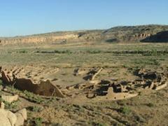
The Anasazi constructed impressive
public buildings known as great houses.
One of the most sacred great houses, Pueblo Bonita, towered four
stories high. It contained over
600 rooms and 40 kivas, or underground religious rooms. Great houses were built with careful
astronomical alignment and followed the directional points of a
compass.
It is
thought that these structures were public buildings used for commerce, trading,
and ceremony. In constructing the
great houses, the Anasazi cut tons of sandstone from the canyon cliffs
and felled over 200,000 trees. But
no one knows how the stones and trees were transported from over 45 miles
away without beasts of burden.
|
|
|
Provided
by Randi Lynn Mrvos from Wikipedia.com
|
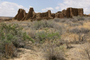
Great
houses were not the only impressive structures that occupied the
canyon. The Anasazi devised a
system of interlocking roads constructed in straight lines. These roads radiated out and stretched
400 miles from Chaco Canyon. Many
roads, especially those closest to the canyon, had a signaling station
and roadside shrines.
But
why were these far-reaching roads constructed? Were the roads used to carry heavy roof
beams to build the great houses?
Did tribes travel them for
religious ceremonies?
In
addition to great houses and interlocking roads, the Anasazi people
developed techniques to distribute water to their fields. They terraced cliffs, built ditches,
and engineered overflow ponds, dams, and irrigation canals. These systems channeled rain from the
flat-topped mesas to the canyon bottom.
But with many ingenious ways to collect water to grow crops, why
did the Anasazi leave Chaco Canyon?
Researchers
speculate that the exodus may have been due to deforestation, or perhaps
over-cultivation of their fields.
Other theories suggest that the Anasazi may have been under attack
by enemies or stricken by disease.
|
|
|
Chaco Canyon
Today from Wikipedia.com
|
The
most popular theory is that a drought forced the Anasazi from the
canyon. After scientists analyzed
the growth rings of ancient trees of the area, they discovered that
rainfall was scarce in 1090 and again in 1130. With no way to raise their crops, the
Anasazi deserted their homes and farmlands. They abandoned the canyon, even though
the rains returned at the close of the 11th century.
Today, Chaco Canyon remains shrouded in
mystery. The Anasazi left no
written records, but if they had, maybe we would be more
enlightened. Was Chaco a resource
center for food distribution during the dry periods? Or was it a trading network? A religious place? Most curiously of all, did droughts
drive the Anasazi Indians from the canyon? Perhaps one day the mysteries will be
solved. But for now the answers
lay hidden among the sacred ruins of Chaco Canyon.
|